Description
Size: 47" x 36"
Scale: 300,000
Edition Date: 02/14/2003
Edition Number: 1
LNM Cleared Date: 05/19/2017
Specifications
Nautical Chart Selector - Select a region from the map below to view other charts

Rebates
There are currently no rebates available for this item
Related Products
Related Accessories


You may also like
-

NOAA Nautical Chart - 14864 Harrisville to Forty Mile Point;Harrisville Harbor;Alpena;Rogers City and Calcite
-

NOAA Nautical Chart - 13286 Cape Elizabeth to Portsmouth; Cape Porpoise Harbor; Wells Harbor; Kennebunk River; Perkins Cove
-

NGA Nautical Chart - 54115 Otok Drvenik Mali to Otok Susak and Porto dAscoli to Porto Corsini
-
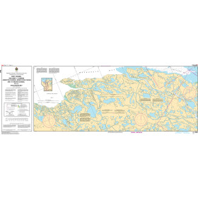
CHS Nautical Chart - CHS6441 West Channel including/y compris Anderton Channel Ministicoog Channel and/et Moose Channel to/a Shoalwater Bay
-
NOAA Nautical Chart - 12358OG New York Long Island Shelter Island Sound and Peconic Bays, Mattituck Inlet