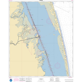
Description
Size: 51" x 36"
Scale: 50,000
Edition Date: 02/27/2009
Edition Number: 6
LNM Cleared Date: 07/07/2017
Specifications
Nautical Chart Selector - Select a region from the map below to view other charts

Rebates
There are currently no rebates available for this item
You may also like
-

NOAA Nautical Chart - 11365 Barataria and Bayou Lafourche Waterways Intracoastal Waterway to Gulf of Mexico
-
NOAA Nautical Chart - 11303OG Intracoastal Waterway Laguna Madre - Chubby Island to Stover Point including The Arroyo Colorado
-

NOAA Nautical Chart - 81071 Commonwealth of the Northern Mariana Islands Bahia Laolao Saipan Island and Tinian Harbor Tinian Island
-

NOAA Nautical Chart - 25663 Pasaje de San Juan to Puerto de Humacao and Western Part of lsla de Vieques
-

NOAA Nautical Chart - 19353 Harbors of Moloka'i Kaunakakai Harbor;Pukoo Harbor;Kamalo Harbor;Kolo Harbor;Lono Harbor