Description
Commercial and recreational boaters alike know that nothing replaces the peace of mind that comes from having a reliable paper chart onboard. These charts are printed on high-quality paper and feature improved detailing and color contrast.
The chart you are viewing is NOT updated weekly and does NOT include all of the latest Notice to Mariners corrections.
- Chart Length: 48"
- Paper Width: 36"
- Scale: 100000
- Content Width: 44.605"
- Content Length: 32.263"
Specifications
Nautical Chart Selector - Select a region from the map below to view other charts

Rebates
There are currently no rebates available for this item


You may also like
-

NOAA Nautical Chart - 16420 Near Islands Buldir Island to Attu Island
-

NGA Nautical Chart - 93284 Approaches To Kampong Saom ( Gulf Of Thailand )
-
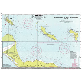
Imray Nautical Chart - Imray-D23 Punta Aguide to Cabo San Roman and the A B C Islands
-

BA-2537 Ghawdex (Gozo) Kemmuna (Comino) and the Northern Part of Malta
-

BA-503 Roatan (Coxen Hole) including Dixon Cove (Mahogany Bay) and French Harbour