Description
France's Naval Hydrographic and Oceanographic Service charts cover waters for many areas of the world, providing commercial and recreational mariners with important navigational information.
Specifications
- Paper Length: 49"
- Paper Width: 36"
- Edition Number: 4
- Edition Date: 01/26/2015
- Scale: 1:35,000
- Content Width: 32.053"
- Content Length: 45.597"
Rebates
There are currently no rebates available for this item
You may also like
-
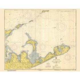
Historical Nautical Chart - 362_7-1951 Block Island Sound and Gardiners Bay
Regular Price: $45.00
Special Price $39.95
-
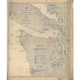
Historical Nautical Chart - 6400-06-1900 Grays Harbor to Semiahmoo Bay
Regular Price: $45.00
Special Price $39.95