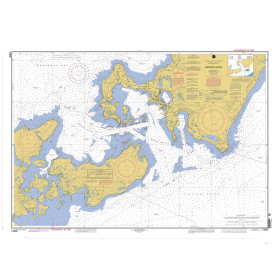
Description
France's Naval Hydrographic and Oceanographic Service charts cover waters for many areas of the world, providing commercial and recreational mariners with important navigational information.
Specifications
- Paper Length: 48"
- Paper Width: 36"
- Edition Number: 0
- Edition Date: 12/28/1995
- Scale: 1:1,500,000
- Content Width: 44.05"
- Content Length: 32.2"
Rebates
There are currently no rebates available for this item
You may also like
-
Historical Nautical Chart - 13235-04-2004 Woods Hole
Regular Price: $45.00
Special Price $39.95
-
BA-AUS52 Entrance Channel to Port Hedland
-

Waterproof Charts - Lower St. Johns River Fishing