Description
France's Naval Hydrographic and Oceanographic Service charts cover waters for many areas of the world, providing commercial and recreational mariners with important navigational information.
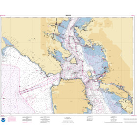
Specifications
- Paper Length: 49"
- Paper Width: 36"
- Edition Number: 2
- Edition Date: 05/19/2009
- Scale: 1:152,000
- Content Width: 31.603"
- Content Length: 45.807"
Rebates
There are currently no rebates available for this item
You may also like
-

NGA Nautical Chart - 71005 Northwest Sumatera and the Strait of Malacca (OMEGA)
-

Historical Nautical Chart - 542-03-1933 Jamaica Bay And Rockaway Inlet
Regular Price: $45.00
Special Price $39.95
-

BA-2326 Loch Crinan to the Firth of Lorn
-

BA-558 Isla Leones to Estrecho de Magallanes including the Falkland Islands
-
NOAA Nautical Chart - 18649OG Entrance to San Francisco Bay