Description
As of December 31, 2024, NOAA has retired traditional paper nautical charts by chart number. While these charts are no longer updated, NOAA continues to maintain and publish all underlying hydrographic data.
In partnership with NOAA, OceanGrafix offers Print-on-Demand (POD) charts that use the latest official NOAA data. Updated weekly, these charts retain the same chart number and are marked with an “OG” suffix, indicating they reflect the most current information available. The OceanGrafix OG charts are printed fresh on premises per order just like we have done for over 10 years and counting.
Each chart features enhanced detail, improved color contrast, and is available on standard or waterproof paper—backed by NOAA’s authoritative data.
For weekly NOAA chart updates, please click here
Click here to access the Zone of Confidence (ZOC) diagram along with important notes. You can either view the information or print it. This chart may or may not contain insets.
Full chart catalogs by region.
Specifications
Commercial and recreational boaters alike know that nothing replaces the peace of mind that comes from having a reliable paper chart onboard. But to be effective, nautical charts must be updated regularly.
Using proprietary technology, OceanGrafix continuously accesses and incorporates NOAAs latest cartographic changes into every chart guaranteeing that our customers are getting the most accurate and up to date information available!
- Chart Length: 49"
- Paper Width: 36"
- Scale: 30000
- Content Width: 46.59"
- Content Length: 35.09"
Rebates
There are currently no rebates available for this item
You may also like
-
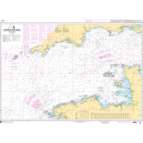
SHOM Nautical Chart 7311 - La Manche (Partie Ouest) - De Isles of Scilly et de lÎle dOuessant aux Casq
-

Patagonia Long-Sleeved Organic Cotton Midweight Fjord Flannel Shirt - Womens
Regular Price: $99.00
Special Price $58.99
-

NOAA Nautical Chart - 25677 South Coast of Puerto Rico Guanica Light to Punta Tuna Light;Las Mareas
-

NOAA Nautical Chart - 17368 Keku Strait-northern part including Saginaw and Security Bays and Port Camden;Kake Inset
-

NOAA Nautical Chart - 17324 Sitka Sound to Salisbury Sound Inside Passage;Neva Str.-Neva Pt. to Zeal Pt.