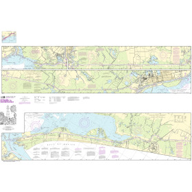
Description
Commercial and recreational boaters alike know that nothing replaces the peace of mind that comes from having a reliable paper chart onboard. These charts are printed on high-quality paper and feature improved detailing and color contrast.
The chart you are viewing is NOT updated weekly and does NOT include all of the latest Notice to Mariners corrections.
- Chart Length: 43"
- Paper Width: 36"
- Scale: 20000
- Content Width: 31.94"
- Content Length: 39.84"
Specifications
Nautical Chart Selector - Select a region from the map below to view other charts

Rebates
There are currently no rebates available for this item
Related Products


You may also like
-

Harken 75mm Fiddle Ratchet Block - Swivel - Becket - Cam Cleat
-

Harken 57 mm Fiddle Ratchet Block - Swivel - Cam Cleat - Becket
-

Navionics Platinum+ XL3 907P+ - Gulf of Mexico
-

NOAA Nautical Chart - 14781 Riviere Richelieu to South Hero Island
-
NOAA Nautical Chart - 11331 Intracoastal Waterway Ellender to Galveston Bay