Description
ADMIRALTY Standard Nautical Charts (SNCs) are the world's most trusted and widely used official paper charts. The range includes comprehensive paper coverage of commercial shipping routes, ports and harbours to help bridge crews safely navigate in accordance with SOLAS regulations.
- ___Over 3,500 ADMIRALTY charts with coverage appropriate for navigation of deep sea, coastal passages, port approaches and harbour berthing.
- A range of scales to provide appropriate levels of detail and increase situational awareness, including: Large-scale charts for main ports and harbours, medium scale charts for coastal navigation and small-scale charts for offshore navigation.
Specifications
Rebates
There are currently no rebates available for this item
You may also like
-

Weems & Plath Chrome Stormglass Display 8x10 Wood Display with engrave
-

Navionics Platinum+ XL3 17P+ - Sweden South
-

NOAA Nautical Chart - 18521 Columbia River Pacific Ocean to Harrington Point;Ilwaco Harbor
-

NGA Nautical Chart - 71009 Singkil to Padang including Adjacent Islands (OMEGA)
-
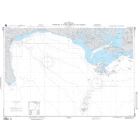
NGA Nautical Chart - 21584 Approaches to Puerto Armuelles and Pedregal