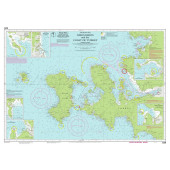
You have no items in your shopping cart.

You have no items in your shopping cart.

FREE Shipping on $100+ Orders Details
Need Help?
Call us at 1-800-941-2219

Imray Nautical Chart - Imray-G40 Kas to Antalya

Imray-G40

Availability: In stock

Imray-G40

Imray Nautical Chart - Imray-G40 Kas to Antalya

PRICE 

$29.50
$29.50 - $44.75

based on selected options

For this edition the chart has been fully updated and modernised. The latest known depths are shown around Kas, Kekova Roads and Antalya Harbour. Harbour depths at Üçagiz are also displayed, as are the recently deployed AIS transmitters across the chart.

Full Imray Mediterranean Chart Catalogue HERE


Chart Paper Choices
  1. Water Resistant paper (WR): Our Standard format.
  2. Waterproof paper (WP): printed on a fully waterproof synthetic material for longer life, stain resistance, and durability. ***if your planning on framing – please select the Waterproof paper version. The colors are much brighter.
  3. Tri-fold paper (TR): comes as a convenient 7" x 12" tri-fold. The length varies by chart number. Note only available on water-resistant (WR) chart paper.

* Required Fields

$29.50

Description

For this edition the chart has been fully updated and modernised. The latest known depths are shown around Kas, Kekova Roads and Antalya Harbour. Harbour depths at Üçagiz are also displayed, as are the recently deployed AIS transmitters across the chart.

Specifications

  • Plans included:
  • Kekova Roads (1:40 000)
  • Kekova Adasi (1:15 000)
  • Finike (1:17 500)
  • Antalya Celebi Marina (1:15 000)
  • Kemer Turkiz Marina (1:17 500)

Customer Reviews

Write your own review

There are currently no reviews for this product. Click the link above to write a review.

Write A Review

Only registered users can write reviews. Please, log in or register

Rebates

There are currently no rebates available for this item

Need Help?
Call us at 1-800-941-2219