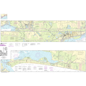
You have no items in your shopping cart.

You have no items in your shopping cart.

FREE Shipping on $100+ Orders Details
Need Help?
Call us at 1-800-941-2219

CHS Nautical Chart - CHS5623 Farther Hope Point to/a Terror Point

CHS Nautical Chart - CHS5623 Farther Hope Point to/a Terror Point

Availability: In stock

CHS5623

CHS Nautical Chart - CHS5623 Farther Hope Point to/a Terror Point

PRICE 

$24.75


At 152,100 miles, Canada has the longest coastline in the world! OceanGrafix and Landfall Navigation have joined forces to provide you with the most up-to-date nautical charts. Canadian charts come directly from the Canadian Hydrographic Service. The standard charts are water-resistant with a tough coating for longer life. Bright colors make them easier to read under varying light conditions.
Canadian Hydrographic Service (CHS) Chart Catalogs
CHS Region 1 Atlantic Coast (.pdf)
CHS Region 2 Pacific Coast (.pdf)
CHS Region 3 Ontario / Manitoba (.pdf)
CHS Region 4 Arctic (.pdf)

* Required Fields

$24.75

Description

Size: 50" x 36"
Scale: 40,000
Edition Date: 11/08/1991
Edition Number: 1
LNM Cleared Date: 12/31/1969

Specifications

Nautical Chart Selector - Select a region from the map below to view other charts

Atlantic Cost Pacific Coast Atlantic Ocean Gulf Coast Mexico Great Lakes Canada Hawaii Central America Alaska Arctic Ocean Pacific Ocean Caribbean South America Antarctica Greenland Iceland Europe Africa Madagascar Australia Russia Asia Svalbard Indian Ocean New Zealand Pacific Ocean Arctic Ocean Arctic Ocean Arctic Ocean Arctic Ocean Arctic Ocean Image Map

Customer Reviews

Write your own review

There are currently no reviews for this product. Click the link above to write a review.

Write A Review

Only registered users can write reviews. Please, log in or register

Rebates

There are currently no rebates available for this item

Need Help?
Call us at 1-800-941-2219