
Description
NA-M035 PACIFIC COAST AND CENTRAL AMERICA
C-MAP MAX electronic charts include detailed navigation data as well as features like dynamic NavAids and tides, Guardian Alarm, and detailed marina port plans. C-MAP MAX provides cruisers, sailors and fishermen with the accurate, up-to-date chart data you need to enjoy each day on the water.
The following chartplotters use C-Map CC (C-Card), SD (Secure Digital), or MSD (Micro Secure Digital) cartridge types.
- C-Map Compatibility Guide (.pdf)
Specifications
If you know you require a C-Map Cartridge but are not sure which one you need, give us a call at 1-800-941-2219. Landfall Navigation® will help you select the correct one.
The following chartplotters use C-Map CC (C-Card), FP (Furuno card), SD (Secure Digital), or MSD (Micro Secure Digital) cartridge types.
C-Map Compatibility Guide (.pdf)
Rebates
There are currently no rebates available for this item
You may also like
-

NHS Nautical Chart - NHS309 Smola - Sklinna
Regular Price: $32.50
Special Price $24.75
-

Helly Hansen HP Racing Deck Shorts - Womens
Regular Price: $100.00
Special Price $60.00
-

C-MAP MAX Bathy - Lake Erie & Lake St Clair
-

Study Book w/ Q&A
-
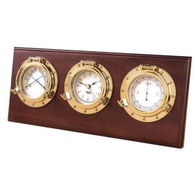
Weems & Plath Porthole Weather Center - 3 instruments